
search
Keikyu line map
Map of Keikyu line. Keikyu line map (Kantō - Japan) to print. Keikyu line map (Kantō - Japan) to download. The Keikyu Main Line runs between south area of Tokyo, Kawasaki, Yokohama, and Yokosuka as its shown in Keikyu line map. Shinagawa Station is the terminal station in Tokyo of Keikyu line. Keikyu line "Kaitoku" (快特) limited-stop service competes with JR East Tōkaidō Main Line and Yokosuka Line. From Sengakuji station, Keikyu trains run into the Toei Asakusa Line and Keisei Electric Railway (to Narita Airport) and Hokuso Railway (to Chiba newtown area) lines.
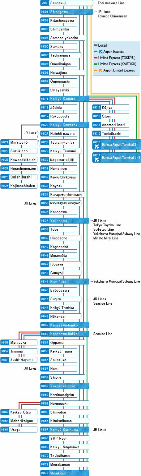
Keikyu line currently serves as part of the Keikyu Airport Line and helps to connect Haneda with Tokyo and Kanagawa Prefecture as its mentioned in Keikyu line map. One feature that distinguishes the Keikyu Main Line from other private railways is the Kaitoku limited express trains. The Keikyu Main Line competes with the JR Tokaido Line and the Tokyu Toyoko Line for service from Tokyo to Yokohama. Among these three, Keikyu line operates at the fastest speed of 120km/h between Shinagawa and Yokohama.
The Keikyu Main Line forms the backbone of the Keikyu Network and connects Sengakuji Station in Tokyo with Uraga Station in Yokosuka City as you can see in Keikyu line map. Keikyu line is one of the major commuter lines for people heading into Tokyo from Kanagawa prefecture and is a major rival of JR and Tokyu Corporation. The first portion of Keikyu line was opened in 1901 and after many extensions, reached Uraga Station in 1930. Stations have been built and closed throughout the years, but it has kept the same general form since the 1930s. In 1968, the Keikyu Main Line was connected with the Toei Asakusa Line which continues on to the Keisei Oshiage Line.