
search
Shinjuku map
Map of Shinjuku. Shinjuku map (Kantō - Japan) to print. Shinjuku map (Kantō - Japan) to download. Shinjuku is one of Tokyo 23 districts and is home to the prefecture government. Centered around the world busiest train station as its shown in Shinjuku map, it combines several faces such as: business district, the hub of Tokyo nightlife and a shopping spot for amateurs. Shinjuku is one of Tokyo most famous districts for several reasons. First of all, the metropolitan government is located in this fascinating economic lung, which hosts 310,000 inhabitants on just over 18 km². This is the "skyline" of the capital: a series of skyscrapers, each one more impressive than the next.
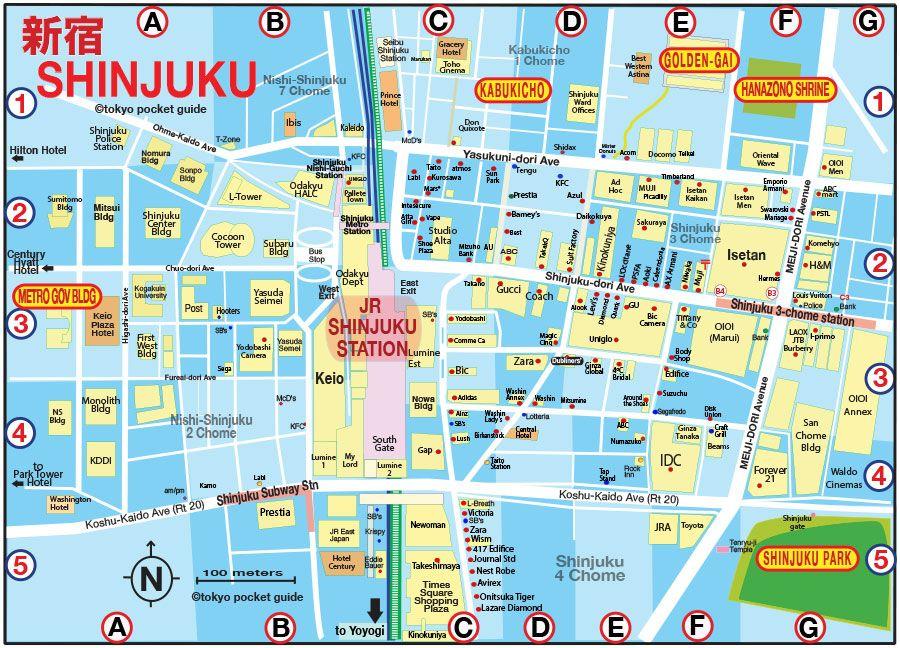
Shinjuku is, along with Shibuya the most cosmopolitan and lively neighbourhood in Tokyo, with its neon lights, fashionable people and 24 hour life. These streets of Shinjuku are the very image of the modernity that we all think of when we picture Tokyo. The electronics shops of Shinjuku are perhaps only rivalled by those of Akihabara as its mentioned in Shinjuku map, but prices are closer to those you might pay in Europe than those of the little shops in the techy neighbourhood.
West of Shinjuku is, known as Nishi-Shinjuku, you can find the tallest skyscrapers in Tokyo as you can see in Shinjuku map. West Shinjuku well worth your while to explore this area, climb the viewpoints of the Metropolitan Government Building and if your budget stretches that far, drink a coffee in the New York Bar in the Park Hyatt Tokyo Hotel, made famous by the film Lost in Translation.
Shinjuku is itself divided into several colorful districts (including Kabukicho, Okubo or Takadanobaba) and is home to one of the largest parks in Tokyo, the Shinjuku Gyoen as its shown in Shinjuku map. Day or night, to go out or discover the electric capital, the district of Shinjuku is a must and its train station, the busiest in the world, welcomes several million passengers every day.